Images of Mining & Life from the Past – II


Continuing the collection of old images of the early mining days in the northern goldfields of Western Australia, mainly the old Sons of Gwalia Mine at Leonora but also many of other surrounding places.

See this link for a map showing Leonora and Gwalia


School Class Pictures

Local Member of Parliament, Dick Burt with Mrs Conlon and her Gwalia Class


Flood 1937

Rail Washout – Malcolm

Malcolm lies east of Leonora towards Laverton and though there is no longer a town, there is still a rail-head. Gold was discovered here in 1895.


Aftermath of Fire in Town (Leonora) July 1932


Bulldozer – Driver “Robbie”


Donkeys at Work at the Mine


Donkey Teams Under Full Load


The Local Doctor’s Method of Transport


Kurrajong Hotel

Old mining town about 28 km (17 mile) NNW of Leonora

A Celebratory Dinner – men only by the looks.


Devine’s Anaconda Store at Euliminna

Eulaminna was an old township east of Leonora along the road to Laverton

Sons of Gwalia Mine Looking somewhat derelict


Train Derailment – Unknown Location


Horse Assisted Flood Crossing – Unknown Location


Camel Travel – Note the Woman’s Dress


Cobb & Co the Australian Equivalent of America’s Wells Fargo


Clem Hill


Central Hotel, Leonora


Carriggs Hotel, Mt Morgan

Known as “Morgans” gold was discovered here in 1896. It was located along the Old Laverton Road in between Leonora and Laverton.


Men and Their Camels 1911


Sons of Gwalia Mine, August 1913


Flooding at Station Creek

North of Leonora Station Creek is now the Town Water Reserve


See a more recent collection of images of Leonora & Gwalia

Images of Mining Life from the Past

Here is the beginning of a collection of old images of the early mining days in the northern goldfields of Western Australia, mainly the old Sons of Gwalia Mine at Leonora but many of other places also.

See this link for a map showing Leonora and Gwalia


Moving a 20 Ton Crankshaft

Before the 1921 Fire


Fire at Sons of Gwalia Mine 1921


1927 Buick Mail Car


1930 Mess Room


Head Frame 1948


Heading Underground in 1963


Sons of Gwalia Mine 1968

Anaconda Copper Mine Eulaminna 1900

Eulaminna was an old township east of Leonora along the road to Laverton

Rail Wash-away 1927 Floods


Afternoon Shift 1930


Allies Set 1916 Gwalia School Ball

Amongst the Wildflowers


Description is wrong £60,000 = $120,000 (AUD) and is today worth over $4,000,000!!


An Outing to Doyle’s Well, about 37 miles (60 km) north west of Leonora

Doyle’s Well Pub Ads


August 1913


Ballangarry Hotel

Balangarry is about 120 km north of Leonora near where Leinster is today


Bank of New South Wales Leonora in two different incarnations


Barnes Federal Theatre

Built in 1899 or Mr P. Barnes, an hotel owner and businessman of Leonora.


Cyclists at Craiggiemore Gold Mine

The old Craiggiemore Gold Mine was located in the Laverton Area


Gwalia Leonora Bus Service


Camel Drawn Plow, Gwalia

The Sign on the plough says Lynas Motors – I don’t know if there was an association with a Perth Ford Dealer of the same name.


Cameleer with his Camel


Camel Train Leonora 1930


Camel Train Wilsons Patch

Wilson’s Patch was about 80 km north of Leonora

Camel Trains = the top image is at the Gwalia Railway Station


A Day Trip to Quairading and Kokerbin (Western Australia) August 2020

All images are geotagged and hyperlinked to open full screen. To view them on a map, save the image to your hard drive and then download this FREE SOFTWARE. Install and click on the image in the left panel to view in a map as to the location where it was taken.  (SAMPLE VIEW)


A day out in the country – see here for the route followed:


Greenhills Cemetery, Quairading-York Road, Greenhills, Western Australia

Grave of Charlotte Keane, Greenhills Cemetery

Grave of William & Mary Ann McMullen, Greenhills Cemetery

Grave of George McMullen, Greenhills Cemetery

Grave of William Boyle – an Infant, Greenhills Cemetery

Grave of William George White, Greenhills Cemetery

Quairading-York Road Westwards, Greenhills Cemetery

St Andrew’s Anglican Church, Quairading-York Road, Greenhills  Built: 1912

Quairading Hotel, Heal Street, Quairading  Built: 1908

Interior of Quairading Hotel

War Memorial, Heal Street, Quairading

Tribute to Pioneers, Heal Street, Quairading

The Co-Op, Heal Street, Quairading

Intersection of Heal Street and Cubbine Road, Quairading

Railway Station, Quairading

Baggage Scales

Track – West & East

Community Centre (Rear View) Quairading

Directions, York-Merredin Road, Quairading

Commemoration Plaque, Heal Street, Quairading

(To commemorate the town’s contribution to the State’s sesquicentenary)

Former Commercial Bank of Australia Premises, Heal Street, Quairading

Premises date to 1937 – the Commercial Bank and Bank of New South Wales merged in 1982 to become Westpac Banking Corporation.

The Brass Razoo Bank, Former Commercial Bank of Australia

An old Australian saying if you haven’t got a “Brass Razoo”, means you are broke or penniless.

Shire Hall, McLennan Street, Quairading Built: 1925

The place was originally the Roads Board office. Throughout the years it has been the focus of social and cultural activities in the Quairading area. The Hall has been the venue for community and celebratory activities which include numerous balls. Dancing was enjoyed at most of the social gatherings. Wedding receptions, dinners, school concerts, cabarets, ballet, live performances, theatre, YAL (Young Australia League) concerts, and Repertory Shows also featured at the hall. Community groups have used the hall for meetings and functions. During World War Two, fundraising and welcome home dances were the main events. Pictures were always a family night out, and remained popular at the hall until the late 1960s when the drive-in theatre opened in Quairading. During the 1979 refurbishment of the hall a cache of cash was discovered in a drainpipe. It is reputed to have been Paddy Baker’s, the picture show man (later owner of the Regal theatre in Perth). The extensions to the hall in 1979 offered more opportunities for the place. The Senior Citizens have established facilities in the former Roads Board offices, and the hall, reception area and lounge are used for many social, civic and community functions.

“El Toro” – A Jordan Sprigg Sculpture, Shire Hall

Former Western Australia Bank Premises, Heal Street Built: 1926

Post Office, Jennaberring Road  Built: 1927

Rock Outcrop, Pantapin South Road, Pantapin

Windmill & Water Tank, Pantapin South Road, Pantapin

Government Well, Kokerbin Nature Reserve, Kwolyin

The well is of a dry-wall construction and is over 20 metres deep and 3 metres wide. It is believed to have been a government project to assist in the early development of the area.

Around Kokerbin Rock, Kokerbin Nature Reserve, Kwolyin

Picnic Area, Kokerbin Nature Reserve, Kwolyin

Rural Landscape, Mount Stirling Road, Mount Stirling

Granite Outcrop, Mount Stirling Road, Mount Stirling


Dowerin & Goomalling, July 2020

Another drive into the country for lunch in the wheatbelt town of Dowerin and a stop at Goomalling on the return to Perth.


All images are geotagged and hyperlinked to open full screen. To view them on a map, save the image to your hard drive and then download this FREE SOFTWARE. Install and click on the image in the left panel to view in a map as to the location where it was taken.  (SAMPLE VIEW)


(view from the pub balcony)


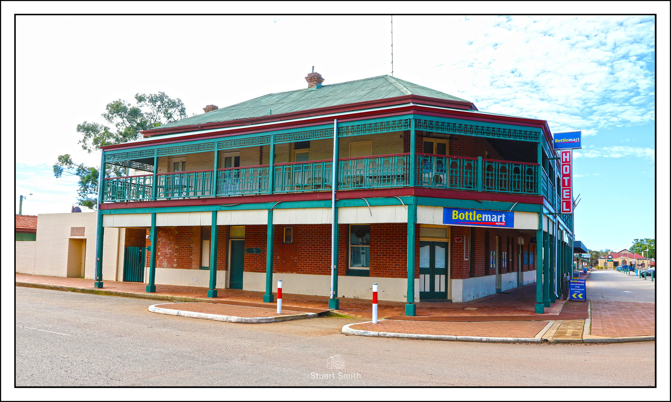
Commercial Hotel, Stewart Street, Dowerin, Western Australia

“Benbullen”, 18 Stewart Street, Dowerin

Post Office, Stewart Street, Dowerin c.1913

National Australia Bank, Stewart Street, Dowerin

Views of Stewart Street, Dowerin

Brush Screen, Stewart Street, Dowerin


Freemasons Hall, Goldfields Road, Dowerin

Sculpture, Stewart Street, Dowerin

I believe it is supposed to represent a stalk of wheat?

Railway Derrick, Stewart Street, Dowerin

Picnic Seating, Railway Reserve, Stewart Street, Dowerin

War Memorial, RSL Centenary Park, Goldfields Road, Dowerin

Road Board Office, Stewart Street, Dowerin, c.1924

The Dowerin Road Board came into existence following the split from nearby Goomalling in about 1912. The land was purchased in 1923 for £500 and the building opened the following year.

These offices were used by the Dowerin Road Board and, later, the Dowerin Shire Council for a period of 44 years. By 1966 the increase in staff necessitated by population growth and additional administrative responsibilities, meant that the old building no longer had adequate space. Plans were ordered for a new administrative building which was opened in April 1968.

Original Commercial Bank of Australia Premises, Stewart Street, Dowerin c.1911

The block of land was purchased by Commercial Bank of Australia Ltd. on 24 June 1909 and a branch opened the same year. The Dowerin branch of the Commercial Bank first occupied a three roomed weatherboard building. During the latter half of 1910, N. Peterson of Subiaco won the contract to erect new brick offices for the bank and commenced work in October of that year. Bank officers moved into their new premises at the end of February 1911.

On October 1, 1982, The Bank of New South Wales and CBA became Westpac Banking Corporation.

Old Buildings, Stewart Street, Dowerin

Grey Nomads, Dowerin

Vintage Advertising, Railway Terrace, Goomalling

Road Board Building, Railway Terrace, Goomalling

The building housed the local Road Board from 1907 – 1967.

War Memorial Hall, Cnr Quinland and Hoddy Streets, Goomalling

A Mechanics Institute was erected at this site min 1911 but was demolished and this Memorial Hall was erected in 1922.

Main Street – Railway Terrace, Goomalling

Goomalling Tavern, Railway Terrace, Goomalling

Goomalling Farmers Club, Cnr Quinlan and Forrests Streets, Goomalling c.1912

Socially significant. The club was constructed to fulfil the need for socialisation and interaction of farmers in the area to help exchange ideas and solutions to problems. Structurally & architecturally significant of the era.

Former Union Bank of Australia and Quarters, Railway Terrace, Goomalling, c.1925

Quite a history behind the Union Bank. Formed in 1837 and operated until 1951 when it merged Zealand Bank Limited- Now the Australia and New Zealand Banking Group, commonly known as the ANZ.

Alley, Railway Terrace, Goomalling

Agricultural Relic, Millsteed Memorial Garden, Cnr Quinlan and Hoddy Streets, Goomalling

The Memorial garden commemorates Terence Millsteed who was a member of the Goomalling Roads Board, a councillor on the Goomalling Shire Council and Shire President from 1940 to 1975.

Possum Sculpture, Railway Terrace, Goomalling

Post Office, Railway Terrace, Goomalling, Western Australia

Abandoned Farm House, Goomalling-Toodyay Road, Jennacubbine


Woodbridge/Guildford, Perth, Western Australia July 2020

Afternoon coffee at the “Riverside at Woodbridge” and then to Barkers Bridge over the Swan River at Guildford.


All images are geotagged and hyperlinked to open full screen. To view them on a map, save the image to your hard drive and then download this FREE SOFTWARE. Install and click on the image in the left panel to view in a map as to the location where it was taken.  (SAMPLE VIEW)


“Woodbridge”, Ford Street, Woodbridge, Western Australia c.1885

Captain James Stirling took up land here in 1829, the same year the Swan River Colony was settled. He named his property ‘Woodbridge’ as it reminded him of the area around the home of his wife’s family in Surrey, England. Stirling had a small cottage built but spent little time there. At the end of his term as Governor in 1839, Stirling left the colony and leased the property to various tenants.

Charles Harper married Fanny de Burgh in 1879 and the following year took up a lease at Woodbridge. In 1883 land was purchased and the Harpers began the construction of a large family home. Two years later, Charles, Fanny, their three sons and one daughter moved into the completed house.

Jetty on the Swan River below “Woodbridge”

Fields around “Woodbridge”

Barkers Bridge, Swan River, Guildford, Perth, Western Australia

Riverside, Barkers Bridge, Swan River, Guildford, Perth, Western Australia


Wagin, Western Australia

A day trip to Wagin, a rural town in the Great Southern region of Western Australia. It is 225 km from the state capital Perth and is well regarded as a wheat and sheep producing region. It came into being in 1889 after construction of the Great Southern Railway and was originally named Wagin Lake. Each year (it beat the pandemic this year) Wagin hosts ‘Woolorama’, an agricultural show which is a major community event.


All images are geotagged and hyperlinked to open full screen. To view them on a map, save the image to your hard drive and then download this FREE SOFTWARE. Install and click on the image in the left panel to view in a map as to the location where it was taken.  (SAMPLE VIEW)


“Bart” The Giant Ram, Wetlands Park, Arthur Road, Wagin, Western Australia

Butterick’s Buildings, Tudhoe Street  c.1912

Post Office, Tudhoe Street

Palace Hotel, Tudhoe Street c.1905

Mitchell Hall Hotel, Tudhoe Street, c. 1895

Mitchell House, Tudor Street

Butterick Building, Tudor Street c.1905

Rotunda, Tudor Street

Galt Drinking Fountain, Tudor Street

This fountain was presented to the Municipality of Wagin in January 1929 by Alexander Galt, an immigrant Scotsman, who operated a hardware importer business in town. It is number 18 manufactured at Walter Macfarlane’s Saracen Foundry in Glasgow, Scotland.

National Australia Bank, Tudor Street

Courthouse, Tudor Street

Moran’s Wagin Hotel, Cnr Tudor and Tavistock Streets c.1900

“Ladies Rest.Room”, Tavistock Street

Rear Garden, Cresswell’s Emporium, Tudor Street

Town Hall, Tudor Street

Wagin District Club, Tavistock Street

Loading Doors, Heritage Building, Tavistock Street

14 Tavistock Street

Rusting Dodge, Tavistock Street

Uniting Church, Ranford Street

Wagin Argus, Cnr Ranford and Tavistock Streets

‘Crumbling’, Wesley Hall, Tavistock Street

Fence Line, Tavistock Street

Street Sign, Tavistock Street

Note the Ram logo – on every street sign in town

St George’s Anglican Church, Lukin Street

St George’s Hall, Cnr Trenton & Tarbet Streets

Council Gardens, Arthur Road

Wetlands Park, Arthur Road

Country Cottage, Trenton Street

Old Industrial Building Windows, Tarbet Street

Masonic Hall, Tarbet Street c.1907

Wheel Rim, Beaurepaires, Tudhoe Street

Community Centre, Tudhoe Street

Originally built for the Union Bank in 1927 and once occupied by Elder Smith & Co. Now a community centre and utilised also by the local RSL.

Street Mural, Trent Street

Wagin Road Board, Trent Street c.1912

“Rustic Furniture”, 76 Tudhoe Street

Derelict Rural Buildings, Great Southern Highway (…and goat)

Railway Tracks

Graffitied Railway Rolling Stock, Great Southern Highway


Leonora Rain Storm Aftermath

Just a brief trip back in time for some images of a pretty heavy dose of rain on 12 February 2014 in Leonora, Western Australia.

See Google Maps position of Leonora [Click me]


All images are geotagged and hyperlinked to open full screen. To view them on a map, save the image to your hard drive and then download this FREE SOFTWARE. Install and click on the image in the left panel to view in a map as to the location where it was taken.  (SAMPLE VIEW)


Tower Street, between Leonora & Gwalia

Goldfields Highway

Goldfields Highway and Nambi Road Corner

Rajah Street

Railway Bridge at Rajah Street

Port Arthur Penal Settlement, Tasmania, Australia September 2004

NOTE: Clicking on any image will now see it open in a new tab and not in the current page.

A break from more recent travels and a jump back to a 2004 trip to Tasmania and visit to the Port Arthur Penal Settlement.

From 1833 until 1853, Port Arthur was the destination for the hardest of convicted British criminals, those who were secondary offenders having reoffended after their arrival in Australia. Rebellious personalities from other convict stations were also sent there. In addition, Port Arthur had some of the strictest security measures of the British penal system.  The World Heritage Committee of UNESCO inscribed the Port Arthur Historic Site onto the World Heritage Register on 31 July 2010, as part of the Australian Convict Sites World Heritage property. Port Arthur is one of Australia’s most visited historical sites, receiving over 250,000 visitors each year.


All images are geotagged and hyperlinked to open full screen. To view them on a map, save the image to your hard drive and then download this FREE SOFTWARE. Install and click on the image in the left panel to view in a map as to the location where it was taken.  (SAMPLE VIEW)


<>Download a Port Arthur Guide Here!<>

The Guard Tower 1835

The Asylum

Junior Medical Officer’s House, Port Arthur Penal Settlement


The Penitentiarty

Lime Kiln & The Master Shipwrights House at the Dockyard

Isle of the Dead, Carnarvon Bay, Port Arthur

Isle of the Dead is a small Island adjacent to Port Arthur, Tasmania, Australia. The isle is historically significant as it retains: an Aboriginal coastal shell midden; one of the first recorded sea level benchmarks and one of the few preserved Australian convict period burial grounds.

Isle of the Dead forms part of the Port Arthur Historic Site. This site is part of Australian Convict Sites and is listed as a World Heritage Property, as it represents convictism in the time of British colonisation.

The Penitentiary

Price’s Kiln, Port Arthur

Built on land purchased in 1886 following the closure of the Port Arthur Penal Settlement by an English potter from Staffordshire, James Price. Following the death of Price, the kiln was used by local fisherman as storage until it in part collapsed. In 1982, it was fully restored but has never been put to use due to the fragility of the historic bricks.